By Rhoda Maurer
Plant Records Supervisor
| About Scott Arboretum
| Mapping Project
| Using GPS
| In Conclusion
The Scott Arboretum of Swarthmore College
|
The Scott Arboretum is a garden of ideas and suggestions. Encompassing more than 300 acres of the Swarthmore College campus and exhibiting more than 2,000 living woody taxa, the Arboretum displays some of the best trees, shrubs, vines and perennials for use in the Delaware Valley. The Arboretum is a living memorial to Arthur Hoyt Scott (Swarthmore class of 1895), president of the Scott Paper Company and an avid gardener who believed there were too few public gardens for the amateur horticulturist. Through a bequest from Arthur Hoyt Scott's family, the Arboretum was formed in 1929.

John W. Nason Garden and Outdoor Classroom
The Arboretum's collections and gardens are uniquely set amidst a busy college campus. Swarthmore College is a small, highly selective college of liberal arts and engineering with a student population of approximately 1300. Founded as a coeducational institution in 1864 by members of the Religious Society of Friends (Quakers), it is non-secretarian but still reflects many Quaker traditions and values. Swarthmore is considered by academicians to be among the best liberal arts colleges in the country.
|

Metasequoia Allée
While the Arboretum's grounds cover over 300 acres, most of our collections are concentrated on 110 acres at the heart of the college campus. Dr. John Wister, the first director of the Arboretum, organized the planting scheme into collections planted by genera. And while a few genera of his original contributions, lilacs, magnolias, tree peonies, rhododendrons, corylopsis and daffodils are still grouped together in botanical collections, many of our collections are now displayed in gardens. In the mid 1980's the collections committee decided that to serve our mission of educating our visitors on the use of better plants for the Delaware Valley we would begin planting our collections in gardens rather than simply generic collections. This would enable visitors to "see" where and how to place plants in situations typical of a home garden.
|
|
The mapping project began as a result of a self-analysis of how we communicate about planting projects and facilities management issues. The Arboretum felt a need to link campus facilities mapping to our plant location mapping via compatible computerization of our system in order to develop better communication tools between departments within the arboretum, campus facilities, architects and contractors helping us all better plan for future building, utility and collections developments.
Prior to this project, plant locations were recorded on hand-drawn MylarÒ maps using a tape measure. We had no means of easily transferring plant location information to facilities staff and outside contractors. Since we did not have real-world, precision locations for our plant locations, physical analysis and verification of their maps was necessary to convey information about impacts and/or developments of our collections. Campus facilities were already keeping and updating computerized maps of buildings, pathways, roads and other hardscape objects. So we needed to find a way to capture that information, while providing them with plant location information and making a useful system for our curatorial and educational needs.
BG-MapÔ offered us a perfect solution. It already has direct links to BG-BASEÔ written into the program, it has expert technical support and is capable of exporting plant location data in a format compatible with the campus facilities mapping software, ApertureÔ. Our campus facilities provided the base map in an AutoCAD MapÒ 2000 file.
We are currently developing import and export schedules for map updates; facilities will provide updates to roads, buildings, pathways, utilities, etc. and we will provide all plant related location updates.
|
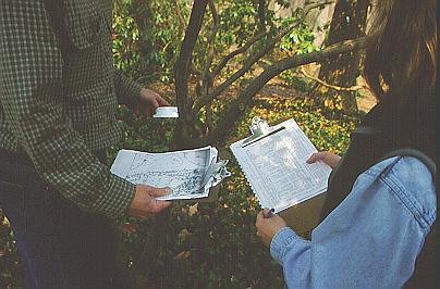
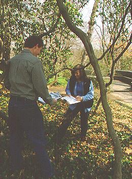 Checking Existing Plant Labels
and Documentation
Because our old system of mapping was based on a quadrant system, all same accessions within any given quadrant were assigned the same qualifier. Our new system requires that locations are exact X-Y-Z coordinates, so each individual of any accession needed to be assigned a unique qualifier. This phase includes analyzing and updating each quadrant's records, verifying the living status of each individual, assigning new qualifiers where appropriate, and making and installing new accessions labels for every plant in our collection. We started this phase one year ago and continue to work ahead of the active creation of computerized maps of our collections. We hope to have most of our 18,000 woody plants mapped in two years.
At that time, we will explore ways to enhance educational links to our computerized plant records information through such applications as world wide web access and touch screen access to our maps that would allow for the creation of self-guided tours.
|
 Checking Existing Plant Labels and Documentation
|
Using a Global Positioning System to Locate Plants
|
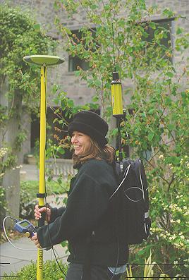 We needed to find a method of locating plants that would transfer precise location information in real world coordinates to our computerized mapping program and our plant records database. We chose to purchase a GPS+GLONASS system since it met the accuracy and one-person operation requirements of the project. The system was purchased from Boyd Instrument & Supply Co., Horsham, PA.
GLONASS is the Russian satellite system while GPS is the American system. We are using a combination satellite receiver so that we can 'read' data from more satellites, thus giving us the ability to get fixed locations in difficult areas with heavier tree canopy or buildings. The system we purchased is a survey grade Topcon/Javad system that gives us accuracies within three inches, exceeding the required accuracy for the sharing of information with our campus facilities mapping department.
The GPS+GLONASS system is comprised of two stations that communicate corrective information with each other via radio. The base station is permanently mounted on the roof of the campus library and required us to register a permanent radio frequency with the Federal Communications Commission.
The rover unit is comprised of a pole mounted GPS antenna, a GPS receiver in the backpack, pole mounted data collector, radio receiver and portable batteries. The location information via the GPS+GLONASS receiver is collected in the data collector using Carlson software.
|
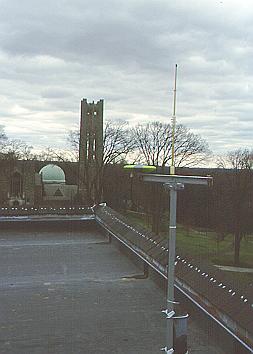 Our GPS Base Station, atop the Campus Library
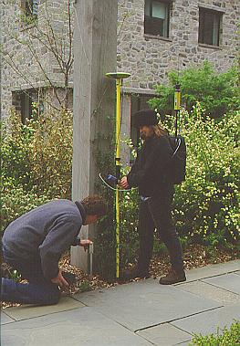 Using the GPS
|
|
Garden Notepad will also be loaded on the data collector in the near future and we will use this to collect information about condition, number of trunks, etc. that will be directly downloaded into BG-BASEÔ.
We will simply toggle between the two programs as we collect the two types of information.
|
We can also choose to only take the data collector in the field and not collect location information simply to collect data about the condition of the plants in the collection. Thus field notes can be directly downloaded to generate reports or update the plant records database, making Garden Notepad a key tool for collections management.
|

