© 2025 Glicksman Associates, Inc. All rights reserved
|
BG-Map
Creating a Basemap |
T
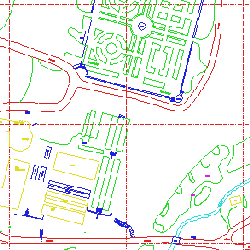
o set up a computerized mapping system, you will need a map of your property in CAD, GIS or other electronic format. This is called a basemap because it serves as a background onto which the plant information is drawn. The basemap must be coordinated with your grid system.Information contained in the basemap can include grid lines, contour lines, buildings, roads, paths, and utilities. This information is usually grouped into a series of separate layers so that the type of information can easily be identified by color and so that some layers can be turned off (removed from the display) when not needed.
The creation of a basemap can vary greatly in complexity:
Starting From Scratch:
If you have no existing accurate maps of your property, you should hire a professional surveyor to create a map for you. This may be done by a combination of aerial and land surveying techniques. Make certain that the surveyor can deliver the map to you in GIS or CAD format so that it can easily be used with your computerized mapping system. Also, you will save time and effort if you provide the surveyor with your mapping system's standards for layering and text formatting. (If you are preparing for a BG-Map installation see
BG-Map Layering Standards.)Converting Existing Paper Maps or Aerial Photos:
If you have reasonably accurate conventional paper maps or aerial photos of your property, they can be digitized (converted into CAD or GIS form) by one of two techniques. The first technique requires that the paper maps or aerial photos be electronically scanned. Using AutoCAD or other software, the scanned images of the paper maps can be overlaid onto a CAD or GIS map. The information on the scanned map is then traced onto the computerized map.
The other technique involves taping the paper map or aerial photo onto an electronic digitizing table and tracing the information.
As the information is copied from the paper map into electronic form, it is grouped into appropriate layers. (If you are preparing for a BG-Map installation see
BG-Map Layering Standards.) Information from a large number of paper maps can be combined to form a single composite electronic map.It is important to keep in mind that the quality of the finished map will be limited by the accuracy of the original paper maps. If the original maps are not accurate, you may wish to consider discarding them and having the property resurveyed.
Using an Existing CAD or GIS Map:
If you are fortunate enough to already have a CAD or GIS map of your property, you should be able to adapt it for use with your mapping system with a minimum of modification.
© 2025 Glicksman Associates, Inc. All rights reserved ![]()
![]()