BG-Map TechNote
How
to Display Unmapped Plants in BG-Map Web-VQF
Updated
3/29/16
This document explains how to allow
visitors to search for and display unmapped plants in Web-VQF.
Creating a Defined View
for a BG-BASE Location
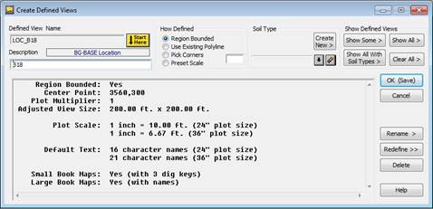
In the BG-Map window, select Tools/CreateDefined
Views. Click “Start Here”, and create a
new defined view. The name of the view
must be LOC_ followed by the BG-BASE code for the Location of the
plant. For example, if the plant to be
displayed is in location BED_29, the Defined View name should be
LOC_BED_29. The designation “BG-BASE
Location” will appear in the Defined View setup window and the only view
definition option will be “Region Bounded”.
Click “Define.” In AutoCAD,
define the view by tracing around the outline of the BG-BASE
location. For details, see “How to
Create a Defined View” in the BG-Map users manual. Once this defined view has been created, all
plants within this location can be displayed.
![]()
![]()