Notes and Suggestions for Botanical
Garden Surveyors - Part 13
By Wayne Cahilly, The New York Botanical Garden
© 2003 The New York Botanical Garden
Wayne Cahilly is
Manager of the Institutional Mapping Department at The New York Botanical
Garden. Please feel free to contact him with any questions at wcahilly@nybg.org
|
|
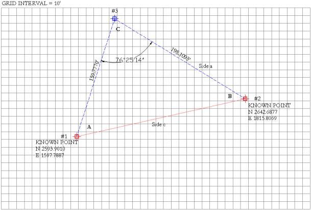
Resection, or Finding the Coordinates of a New Control Point |
|
|
The term “Resection” is used to describe the
practice of identifying the coordinate location of a new control point or
monument from two established points. Frequently surveyors discover that the
work that they need to accomplish is not visible from the control points
previously set and thus they need to establish a new point on which to set up
their instrument. The resection method of establishing coordinates is one
method that can be used to place coordinates on a new point. This method
assumes that you can see two existing control points (#1 & #2) from the
proposed new point #3. The diagram
below provides the “known” information referred to in step #2. All additional
information needed will be calculated in the steps below.
Step 1 Set instrument on
new control point # 3 and back sight control point #1. Set your backsight
azimuth on the instrument to read 0.00'00". Measure the
distance from #3 to #1. Rotate instrument
to control point #2. Record horizontal
azimuth. Measure the
distance from #3 to #2. Step 2 After collecting
data in the field, what do you know? You have the distance from your new
control point to each of the established points, and you have measured the
internal angle (C) between the two lines of sight. You also know the
coordinates of control point #1 and #2, although BG-Map and AutoCAD work with
the order reversed from your surveying instrument. To calculate the location
of point #3, reverse the coordinates to read Y - X as shown on this diagram. Step 3 Next, you need to
calculate the length of the line between your two known points (between #1
and #2). To do this use the following equation:
Thus: (2593.9010 -
2642.6877) + (1597.7887 - 1815.8069) = 49,912.0776. The square root of 49,912.0776 is 223.4101. Line #1 - #2 is
223.4101 feet in length. Step 4 Calculate the
Azimuth of the line #1 - #2 using the following formula:
This results in the
following:
or 4.4126, which is
the inverse tangent, or Arc tangent of the azimuth of the line. By using the
Arc tangent or inverse tangent facility on a calculator, the result will be
an azimuth of 77.23' 11". For calculating purposes, calculate the
decimal equivalent, which is 77.3864.
The next exercise
is to calculate the value of internal angle "A". The formula for
this is:
= -1.7002 which is
the tangent of internal angle "A". Use the inverse tangent or Arc
tangent function to arrive at -59.5378. This is a decimal equivalent of -59d
32'16”, which is the value that would be measured in the field for internal
angle "A". NOTE: The value for
internal angle "C" as recorded in the field was 76d 25' 14".
This must be converted to its decimal equivalent before generating sine or
cosine values for factoring. Step 6 Figure the azimuth of line #1 - #3 by adding the decimal value of internal angle "A" to the calculated decimal azimuth for line #1 - #2. Thus, -59.5378 + 77.3864 = 17.8486, which is the decimal azimuth for line #1 - #3 as viewed from the position of "known point #1". Add this value to the decimal azimuth for internal angle "C". Subtract the combined value from 180.0000 to discover the value of internal angle "B" which should be 85.7309 decimal degrees. Step 7 The last step is to
calculate the Latitude and Departure of the new point from the location of a
known point using the information generated thus far. We will calculate the
latitude and departure of point #3 beginning from point #1. The formula for calculating the Latitude, or distance away in the north/south direction is; Latitude = Distance x cosine of the decimal azimuth. Thus, this factor for point #3 is 159.7770 x 0.9519 = 152.0869 The formula for
calculating the Departure, or distance in the east/west direction is;
Departure = Distance x sin of the decimal azimuth. Thus, this factor for
point #3 is 159.7770 x .3065 = 48.9721. Finally, Add the
Latitude value to the North coordinate of point #1 and the Departure value to
the East coordinate and the resulting values are the coordinates for newly
established Point #3. 2593.9010
+ 152.0869 = N 2745.9879 1597.7887
+ 48.9721 = E 1646.7608 The final redundant
check is to calculate the reverse azimuth for line #1 - #2 by adding 180 to
the decimal equivalent of 77d 23' 11". The resulting value of 257.3864
is the decimal equivalent of the reverse azimuth. Add to this the calculated
value for internal angle "B" to derive the decimal azimuth of line
#2 - #3 and again, calculate the latitude and departure values and add them
to the appropriate Northing and Eastings for point #2. They should result in coordinates
for point #3 that are very close to those obtained in the previous work.
There will be some variation due to rounding within the formulae. That can be
factored out by balancing, but that is for another day...... |
|
|
|